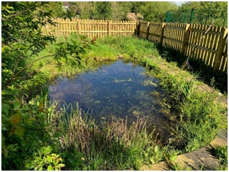
Wetlands
Although we have wet land in Addingham, especially after heavy rainfall, we have little “wetland” habitat. Wetland is a distinctive type of wildlife habitat defined as areas of land with wet soils that are covered by water for parts of the year or all year round.
Wetlands are biologically rich supporting plant species adapted to living in wet soils such as flag iris, meadowsweet and reedmace and home to a wide range of invertebrates, amphibians and birds.
Over the last century many wetlands in the UK have been drained and damaged. Some have disappeared other have been polluted and invaded by non-native species.
In Addingham we have three wetlands of note, Sea Moor Tarn, Beever Pond and the Primary School Jubilee Nature Reserve. Plans by Yorkshire Water to improve sewage treatment may involve building a “constructed wetland” at Low Mill. This would be designed to remove faecal bacteria and nutrients from wastewater and, at the same time create a wildlife habitat.
Sea Moor Tarn
In Addingham our most important wetland is Sea Moor Tarn. It’s sometimes called Brown Bank Marsh. It is located between Addingham and Silsden on the Moorside bounded on the west by Lippersley Lane. It is designated by Bradford Council (under the name “Brown Bank Marsh” as a Local Wildlife Site (LWS). The site has stands of Carex rostrata and nesting snipe and reed bunting. Click here for more information.
Beever Pond
Beever Pond is the site of a medieval pond located on a headwater of Hall Gill, a tributary of Lumb Beck, which itself is a tributary of the Wharfe, just upstream from Ilkley. The pond was used to provide a water supply for iron workings at Plumtree Banks lower down Hall Gill. An earth bank was constructed to hold back the water and create the pond. At a later time, probably in an attempt to drain the pond, the outlet has been lowered. It is now a tall-herb fen dominated by stands of reedmace (Typha latifolia).
School Jubilee Wetland Nature Reserve
 Work on the Primary School wetland nature reserve began in early 2020, just before the start of Covid-19 lockdown, on a site in the north-east corner of the school grounds formerly used, when the school was a Middle School, for athletics (high jump and long jump). Volunteers cleared patches of brambles and removing buried pieces of astroturf and concrete and a contractor was brought in to create a series of wetland hollows of different depths.
Two were fitted with butylite liners to create ponds and nine were left as scrapes. These were planted by Year 3 pupils with purple loosestrife, hemp agrimony, meadowsweet and other wetland species.
The whole site is protected by a perimeter fence and the large pond (which has a maximum depth of 50 cm) has itself been fenced off. For more information click here.

